Strathnairn Community Council Objection (Part 2/3)
Here is the second part (of three) of the Strathnairn Community Council objection, highlighting some critical issues.
3.1 ON CONCEALING & MISLEADING INFORMATION TO REDUCE LANDSCAPE & VISUAL IMPACT ASSESSMENT (LVIA)
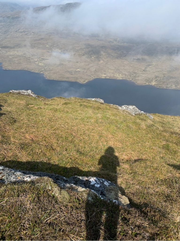
● Tucked in the back of the wider report under ‘Additional information’ is amongst the most revealing of the visualisations.
● This is Figure 1.3 Meall Fuar-Mhonaidh Summit NS (NatureScot).
● AI+A1.3+GE+VP01-Meall+Fuar-mhonaidh+summit+NS.pdf (https://s3.eu-west-1.amazonaws.com/docs.glenearrach.energy/Additional_Information/AI+A1.3+GE+VP01-Meall+Fuar-mhonaidh+summit+NS.pdf)
● This is core to any consultee’s understanding of the proposal, and should be included in all the core information and form part of the main report.
● Particularly when it states:
● The Special Qualities of this SLA are identified in the citation as follows:
“Most of the hills and high points along the enclosing ridges are indistinct in character, however Meal Fuar-mhonaidh is one example of a distinct hill peak, nearly 700m high, it stands out as a landmark clearly visible from both ends of the loch and is even prominent in views southwest from the castle in Inverness. Meall Fuar-mhonaidh is a good vantage point from which to appreciate the massive scale and alignment of the Great Glen fault within a backcloth of the Monadhliath massif to the south and the Balmacaan and Affric mountain interior to the northwest, both areas which possess wildness qualities.”
● Visualisations under Volume 4, show something of the extent of the (negative) impact from Meall Fuar-Mhonaidh Summit across 1a + 1b.
● Again under Volume 4 – visualisations – this captures only something of the extent of the (negative) impact from Glen Coltie; with regards to the dam walls etc.

Overlooking Loch nam Breac Dearga and the Balmacaan Mountain Interior from the summit of Meall Fuar-Mhonaidh (with some cloud inversion)
Objection:
● Figure 1.3 shows – more than any other visualisation – the significant negative impact on the existing landscape; and as stated in the Developer’s report in 7.1.51 proposed on ‘Undeveloped land’.
● Undeveloped land = natural habitats and undisturbed ecosystems.
● Across the development phase and thereafter this development WILL significantly impact receptors – not only flora and fauna associated with the area (see section on natural habitats) – but also the diverse human user group who summit / value Meall Fuar-Mhondaidh which appear to have been scoped out (with the exception of locally impacted residents).
● These are:
○ Community A Guided Walk to the top of Meall Fuar-mhonaidh by Loch Ness, Meall Fuar-mhonaidh, Inverness, 31 August 2024 | AllEvents (https://allevents.in/inverness/a-guided-walk-to-the-top-of-meall-fuar-mhonaidh-by-loch-ness/200026914945936?ref=organizer-new-past)
○ Hillwalkers Meall Fuar-mhonaidh, near Drumnadrochit (https://www.walkhighlands.co.uk/lochness/Mealfuarmhonaidh.shtml)
○ Walk Report – Loch nam Breac Dearga circuit • Walkhighlands (https://www.walkhighlands.co.uk/Forum/viewtopic.php?t=56986)
○ Ramblers Meall Fuar-mhonaidh – Ramblers (https://www.ramblers.org.uk/go-walking/group-walks/meall-fuar-mhonaidh-0)
○ Hillrunners Ultra X Scotland 2026 | Epic Ultra Marathon Trail Race in Scottish Highlands Of 2022 Ultra X; with a planned return to Meall Fuar-Mhonaidh and the Great Glen in 2026: ‘Ahead of them lay 74km, 2,132m of elevation and some of the most beautiful views of the Scottish Highlands. ( https://ultra-x.co/blog/ultimate-scottish-ultra-marathon-adventure-returns-in-2026/)
○ The course took the runners from the city of Inverness largely down the Great Glen Way, with an added climb up Meall Fuar Mhonaidh before they then descended to the shores of Loch Ness to spend the night at camp in Fort Augustus.’
○ Visitors / Tourists Meall Fuar Mhonaidh | Visit Inverness Loch Ness (https://www.visitinvernesslochness.com/listings/meall-fuar-mhonaidh-0)
3.2 ON WILDNESS & SPECIAL LANDSCAPE AREAS OF THE GREAT GLEN & SURROUNDS
● There is an acknowledgement that this development sits within a SLA; and in close proximity to neighbouring SSIs.
● Despite proposed mitigating measures; once developed, these areas are either negatively impacted or are forever lost.
● See 6.5.26
● There is also significant cultural heritage, wild land and prominent landscape features associated with the area (Loch Ness, The Monadliaths, Affric-Kintail, Balmacaan mountain interior area).
● Figure 6.4: Landscape Designations and Operational Zone of Theoretical Visibility (Volume 3: Figures)). An overview of this SLA and key characteristics have been set out within the Assessment of Highland Special Landscape Areas.
● On the Great Glen:
● This document states that: In addition to the key characteristics of the SLA, the special qualities focus on less tangible and experiential aspects of the landscape considered to contribute strongly to what is special about the area.
● The Special Qualities of this SLA are identified in the citation as follows:
“Most of the hills and high points along the enclosing ridges are indistinct in character, however Meal Fuar-mhonaidh is one example of a distinct hill peak, nearly 700m high, it stands out as a landmark clearly visible from both ends of the loch and is even prominent in views southwest from the castle in Inverness. Meall Fuar-mhonaidh is a good vantage point from which to appreciate the massive scale and alignment of the Great Glen fault within a backcloth of the Monadhliath massif to the south and the Balmacaan and Affric mountain interior to the northwest, both areas which possess wildness qualities.”
Objection:
● Again as per the significance of Meall Fuar-Monaidh, the Balmacaan mountain interior and its associated landscape, a diverse human user group – as receptors – appears to be disregarded / readily scoped out and / or is considered not to be significantly impacted.
● By contrast all the human receptors (local, visitors or tourists) on the following routes or in visiting the following destinations which pass through or lie in close proximity to the active sites will be negatively impacted.
● This will be caused by disturbance / change to the environment, increased construction traffic and works disruption, visual impact and sound.
● These routes / destinations include:
Loch Ness 360:
The All New Loch Ness 360° Trail | Loch Ness 360 (https://lochness360.com/)
Epic Ride, Unforgettable Views: Etape Loch Ness Draws Thousands to the Highlands – Caledonian Concepts (https://www.caledonianconcepts.co.uk/2025/04/27/epic-ride-unforgettable-views-etape-loch-ness-draws-thousands-to-the-highlands/)
Great Glen Way:
Great Glen Way (https://www.greatglenway.com/) ‘With 79 miles of path, track, canal and loch to discover, the Great Glen Way has something for all wayfarers. Whether travelling by boot, boat or bike, get set for your own special journey.’
Great Glen Way – Scotland’s Great Trails (https://www.scotlandsgreattrails.com/trail/great-glen-way/)
Great Glen Way (Walkhighlands) (https://www.walkhighlands.co.uk/great-glen-way.shtml)
Urquhart Castle:
Urquhart Castle | Historic Environment Scotland (https://www.historicenvironment.scot/visit-a-place/places/urquhart-castle/)
● This is over and above the known negative impact to the wildness associated with this natural environment, and the flora and fauna it hosts.
● This is further backed up by Brian Shaw’s report – raising concerns about the future and cumulative impact of PSH on Loch Ness – from the Ness Salmon Fishery Board.
3.3 ON ACOUSTIC & VISUAL IMPACT FOR USERS OF MEALL FUAR-MHONDAIDH
● See Figure 2.9 Headpond Arrangement Plan Layout1-A; Figure (https://d2nb274uqw3kq8.cloudfront.net/Volume_3_Figures/Figure_2.9_Headpond_Arrangement_Plan.pdf)
● At a contour change of just 206m from the Summit of Meall Fuar-Mhondaidh (at 696m) and Loch nam Breac Dearga (at 480-490m), and at a distance (on plan) of 366m away from the summit (significantly less on the route up, if and when the dam is constructed (see visualisation submitted to NS) how can airbourne, groundborne and impact sound appear to not be factored in – from here – or has been scoped out?
● This development and the construction of the headpond will visually and acoustically – significantly and permanently – affect this group of users / receptors / community interest.
● From the Meall Fuar-Mhondaidh ridge, summit or surrounding circuits, any user will be completely exposed to the full construction works, visual disturbance, acoustic disturbance, path creation and rerouting, from the planned creation of borrow pit and associated explosions planned for extraction, to the mass civil engineering works in the construction of the main dam and two further saddle dams and the upper control works.
● In flooding – whilst depending in part on the topography – the headpond then increases the plan area of the (already) prominent / existing Loch Nam Breac Dearg x 10 in area; and requires 3 large engineered structures to retain this. This is a significant / impactful change.
● At present in plan area Loch Nam Breac Dearg – as exists and as part of the North Loch Ness Lochs and Lochans – is an equivalent body and stretch of water (of a similar length but near double the width and therefore a larger footprint) to Loch Ceo Glais, on South Loch Ness – to lend scale.
● The proposed borrow pit alone occupies atleast half of the plan footprint of the existing Loch Na Breac Dearg. It is not only extensive (and deep) – and will be seen – but is sited in close proximity to the summit and ridges of Meall Fuar-Mhonaidh.
● This LVIA will be felt and will be significant.
See Figure 2.12 Headpit Plan and Borrow Section Layout1-A
● Post construction with a proposed Top Water Level of 518m, this drops the level change to the summit to 181m; and significantly less across the ridge to access the summit on ascent.
● Vol 5 14.3 Acoustic Model Input Data, not only demonstrates how much plant will be needed on site simultaneously, but also reveals that there is a proposed 4 hour
construction window on Saturday mornings, in addition to the permission being sought at length daily / mid week.
● This will compound things / negatively impact hillwalkers and other users of Meall Fuar-Mhonaidh, in addition to wildlife.
Overlooking Loch nam Breac Dearga and the Balmacaan Mountain Interior from the summit of Meall Fuar-Mhonaidh (with some cloud inversion)
Objection:
● Why is no single or (better still) a series of cross sectional drawings made, showing the critical relationship of the proposed Headpond to Meall Fuar-Mhonaidh (summit and ridge); instead only a cross section from Main Dam to Saddle Dam?
● Why has the acoustic impact not been assessed here (only for isolated properties, rural accommodation or neighbouring settlements in the area)?
● This again conceals the relationship of the planned development works and its impact on the surroundings
● This omission minimises greatly what is presented as the ‘perceived’ or real impact.
3.4 ON SIGNIFICANT & ADVERSE EFFECT TO LOCH NESS & COMMUNITY / BUSINESS / TOURISM
● Appendix 19.1 Mitigation Register, Chapter 16 ST01-10 on Socio-Economics, Recreation & Tourism opens with “Outline the complaint procedure and the channels for the community to make complaints regarding construction activities”.
● This does nothing to mitigate the negative impact – on the above – in the first place.
● Appendix 16.1 On Tourism and Recreation, determines the tailpond site to be at 1km or thereby from several significant tourism businesses in Foyers.
● Equally with the site at only 3.6km from Urquhart Castle; described as simply as:
● “Tourism is one of our most important industries – an economic and social powerhouse that helps sustain communities, creates jobs and attracts investment. It is critical then, that we come together across industry and the public sector to encourage responsible travel, inspire visitors to discover more of our region, stay longer, visit year-round and take time to really immerse themselves in the destination. Visit Inverness, Loch Ness are an important partner for us to work with, collaboratively supporting businesses to grow the value of tourism to Scotland, helping create better places for people to live, work and visit.”
Chris Taylor, Destination Development Director, Highlands & Islands, Visit Scotland
● Discreet from Visit Scotland, locally a prominent BID group has been firmly established who directly promote ‘Visit Inverness / Loch Ness’.
● Their promotion includes Meall Fuar Mhonaidh | Visit Inverness Loch Ness (https://www.visitinvernesslochness.com/listings/meall-fuar-mhonaidh-0)
Objection:
● Across the LVIA & EIA (even down to the telling visualisations over the water from Foyers) the adverse impact on this core industry (tourism) and its contribution to this area and Highland economy is not fully appreciated.
● Tourism – and the associated economy it brings and areas – not only to the proposed shore side of the development – but also on the water and to the South West of Loch Ness (Stratherrick & Foyers) will be affected.
● This needs to be better understood and assessed within this application.
3.5 WHAT TOURISM AT LOCH NESS CONTRIBUTES TO THE AREA & WHAT IS AT RISK 12
● Appendix 16.1 On Tourism and Recreation cites Urquhart Castle as “Ruined castle dating to the 13th century overlooking Loch Ness with visitor centre and café.”; and critically at only 3.6Km east of the Development Site.
● Cross reference this with the Traffic management plan and Acoustic Model Impact, to see how the development will negatively impact this income generating gem; and equally what this ‘attraction’ brings to the area by way of visitors (which will invariably suffer a loss).
● Historic Environment Scotland’s Urquhart Castle is located directly on Loch Ness; near Drumnadrochit, at the foot of Meall Fuar-Mhonaidh and the Great Glen Way, and in close proximity to the planned construction site which forms the access to the tailpond (of Loch Ness).
● Visitors to Urquhart Castle (alone and by way of an example) are reported as 473,814 in 2024; according to the Association of Scottish Visitor Attractions. Heritage Sites and Film Locations Enjoy Surge in Visitor Numbers (https://www.asva.co.uk/heritage-sites-and-film-locations-enjoy-surge-in-visitor-numbers/)
● This places Urquhart Castle at No.5 in the top 10 paid admission attractions in Scotland over 2024; and just ahead of Culloden Battlefield at 374,443 (and at No.6). Both are real draws to Inverness / Loch Ness.
● Sample entry costs to Urquhart Castle are £14.50 per adult visitor – or £41.50 for a family – and tickets MUST be booked in advance to guarantee an entry, state HES.
● Business Minister Richard Lochhead said: ‘These figures hammer home the strength and breadth of Scotland’s Tourism Sector’.
● See The 10 Scottish attractions and castles where visitor numbers are surging – including Outlander site (https://www.scotsman.com/heritage-and-retro/heritage/the-10-scottish-attractions-and-castles-where-visitor-numbers-are-surging-including-outlander-site-5030102)
● Heritage and film locations see surge in visitor numbers | The Herald (https://www.heraldscotland.com/news/national/25000941.heritage-film-locations-see-surge-visitor-numbers/)
Objection:
● The significant impact on the tourism industry to the local economy is not offset by short term local gains / estimated spends on local goods etc over an 8 year proposed construction period.
● Much of the workforce – as stated – is expected to be temporary / transient and come in from elsewhere.
● Therefore it is the displacement of one activity for another; and there will be recognised losses (to livelihoods and economy) within the community.
3.6 ON CONSTRUCTION TRANSPORT, WORKS & ASSOCIATED DISRUPTION
● See Volume 3 – Figures.
● The construction plan makes allowance for the formation of a site workers base or compound; located on the Balmacaan Estate off the A831.
● It allows for 1,000 people to be based / accommodated on the site – for the duration of the works – and is intended to reduce demands on the village of Drumnadrochit and its associated services.
● It is proposed that this works accommodation will be set up as a temporary satellite village with all services / utilities it requires housed directly on the estate; and it is implied that workers will be transported from Inverness to the site (utilising a transport sharing scheme).
● Regardless of these mitigating measures this still puts a significant strain on the local community which can not be readily scoped out or overturned.
Objection:
● Tourists / visitors and locals are entirely dependent on the A831 – as one of only two access routes in which run either side of River Glass / Strathglass – to reach Cannich, Tomich and Affric; along with the neighbouring communities located in advance of this (of Milton, Balnain, Bearnock, Corrimony etc).
● Despite proposed mitigating measures, developing Glen Earrach PSH, with the planned construction of both headpond and tailpond structures, means that construction traffic will need to be mobilised between any workers accommodation / compound on the Balmacaan estate, along the A831 to the proposed location of the tailpond works on Loch Ness off the A82.
● Therefore – invariably – there will be a constant ‘works’ presence predominantly encountered as traffic – moving plant, materials and labour – between the workers accommodation / Balmacaan Estate, accessed off the A831 to join the A82.
● This results in a substantial increase in transport, haulage, deliveries through Drumnadrochit, not only directly impacting the village, compounding the volume of traffic on the only road route round Loch Ness, but also directly passing the only access to Urquhart Castle, to reach the tailpond site; and if accessed from the South, will have a similar effect on Invermorison and Fort Augustus.
● This is over and above what will be a significant disruption – through major and extended construction works – at the location of the live site operating on Loch Ness itself and within close proximity to HES’s Urquhart Castle.Urquhart Castle | Historic Environment Scotland (https://www.historicenvironment.scot/visit-a-place/places/urquhart-castle/)
● To understand the visitor numbers – 473,814 in 2024 – plus contribution to the Scottish economy that these significant regional attractions bring to the area and what will be compromised see Heritage Sites and Film Locations Enjoy Surge in Visitor Numbers
● In addition to the predicted traffic increases – affecting local community, local business and the tourism industry – there will be a predicted and increased load on other neighbouring routes to access either site (the A833 etc).
● Furthermore, this development is stated as being ‘dependent’ on a parallel project; work to adapt the Ness Weir at Dochfour to ‘optimise the efficiency from the cumulative effect of PHS on Loch Ness and provide better resilience against the known effect of climate change’.
● If any further works are planned to Ness Weir – beyond those which have been carried out recently by Scottish Canals – will put an additional load on the A82 of works traffic See Ness Weir- Statera | Strathnairn Community (https://strathnairn.org.uk/ness-weir-statera/) & Scottish Canals | Safeguarding Caledonian Canal’s 200-year-old Ness…( https://www.scottishcanals.co.uk/about-us/maintaining-and-developing-the-canals/our-projects/safeguarding-caledonian-canals-200-year-old-ness-weir
● Through any further works to Ness Weir, or through haulage of excavated materials from the site – via Loch Ness / the Caledonian Canal – this will invariably effect another major tourism business and local employer: An Talla / Jacobite Cruises / Loch Ness.
● In 2024, Jacobite Loch Ness Cruises welcomed around 300,000 people. By May 2025, they are confirmed to have welcomed 20% more visitors than in the first five months of 2024. Jacobite Loch Ness Cruises: Inside firm’s MASSIVE growth (https://www.pressandjournal.co.uk/fp/business/local/6768884/jacobite-loch-ness-cruises-50th-anniversary-interview/)